![](/images/other/stat-length.png)
![Tour Wandern Val de Chaise - D'Albertville à Thônes 3/4 - A l'assaut du Mont Charvin - Photo](https://media.geolcdn.com/t/1900/400/ext.pjpeg?maxdim=2&url=https%3A%2F%2Fservices.sitytrail.com%2FGeolivesWS%2FDownloadMedia.ashx%3FTrailID%3D109632%26Media%3D4273_1.jpg)
D'Albertville à Thônes 3/4 - A l'assaut du Mont Charvin
tracegps
Benutzer
![Länge](/images/other/stat-length.png)
![Maximale Höhe](https://static1.geolcdn.com/siteimages/upload/files/1508320355ic_sort_altitude_max_24dp.png)
![Positive Höhendifferenz](https://static1.geolcdn.com/siteimages/upload/files/1508320355ic_sort_den_pos_24dp.png)
![Km-Effort](/images/other/stat-length.png)
![Min. Höhe](https://static1.geolcdn.com/siteimages/upload/files/1508320355ic_sort_altitude_min_24dp.png)
![Negative Höhendifferenz](https://static1.geolcdn.com/siteimages/upload/files/1508320355ic_sort_den_neg_24dp.png)
![Boucle](https://static1.geolcdn.com/siteimages/upload/files/16400158638029165_repeat_loop_refresh_sync_direction_icon.png)
![Wandern](https://static1.geolcdn.com/sitytour/trail-icons/101.png)
8h00
Schwierigkeit : Sehr schwierig
![Scannen Sie diesen QR-Code, um die Tour in der SityTrail-Anwendung zu öffnen](https://capi.geolives.com/qq0zvz2zws4bq2lad0pu/sitytour/trails/109632/qr.png?size=200)
Kostenlosegpshiking-Anwendung
Über SityTrail
Tour Wandern von 14,5 km verfügbar auf Auvergne-Rhone-Alpen, Hochsavoyen, Val de Chaise. Diese Tour wird von tracegps vorgeschlagen.
Beschreibung
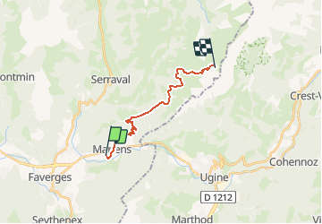
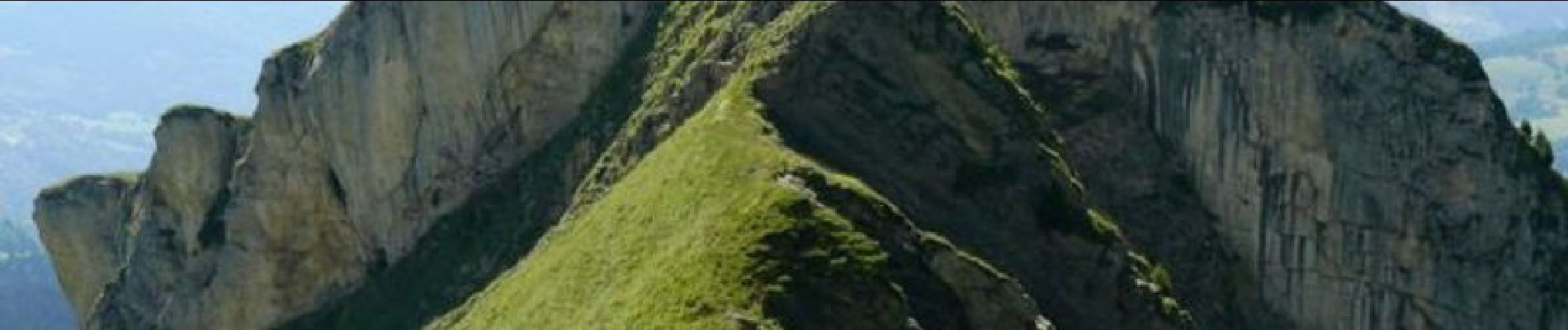
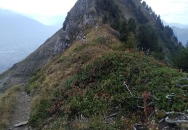
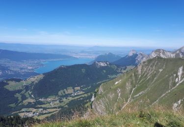
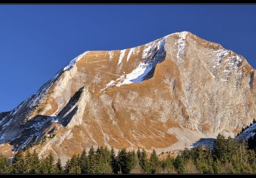
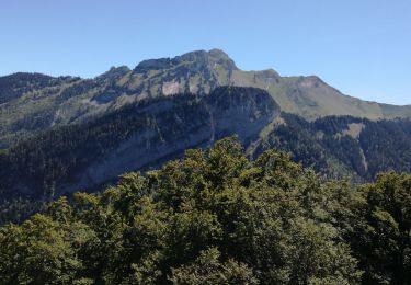
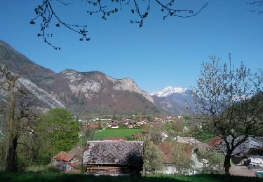
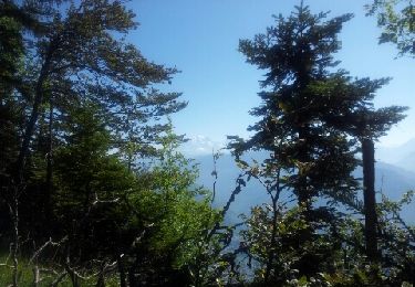
D'Albertville à Thônes 3/4 - A l'assaut du Mont Charvin. L'étape 3 de notre périple, un départ depuis le camping du Champ Tillet situé sur la commune de Marlens où nous avons passé un séjour (2 nuits et une journée de repos) réparateur. Merci au restaurant du camping pour leur accueil est leur gentillesse. Nous partons pour rejoindre lac du Mont Charvin (2011 m) dans le massif des Aravis où nous comptons bivouaquer. Difficulté de la journée : pas de dénivelé descendant, on grimpe sur tout le parcours !!! Objectif : la vue depuis le pas de L'ours nous promet une vue magnifique sur la chaîne du Mont Blanc... Retrouvez toutes les informations nécessaires sur le site de la Communauté des Crapahuteurs.
Ort
Kommentare
Touren in der Umgebung
![Tour Wandern Faverges-Seythenex - Cret des Mouches - Photo](https://media.geolcdn.com/t/375/260/ext.jpg?maxdim=2&url=https%3A%2F%2Fservices.sitytrail.com%2FGeolivesWS%2FDownloadMedia.ashx%3FTrailID%3D322242%26Media%3Dfix__20140706145120.jpg)
![Wandern Wandern](https://static1.geolcdn.com/sitytour/trail-icons/101.png)
Wandern
![](/images/other/stat-length.png)
![](https://static1.geolcdn.com/siteimages/upload/files/16400158638029165_repeat_loop_refresh_sync_direction_icon.png)
![Tour Wandern Marthod - Dent de Cons en boucle depuis Raffort - Photo](https://media.geolcdn.com/t/375/260/539a6901-e25f-4c28-a19b-41b061e5bac8.jpg&format=jpg&maxdim=2)
![Wandern Wandern](https://static1.geolcdn.com/sitytour/trail-icons/101.png)
Wandern
![](/images/other/stat-length.png)
![](https://static1.geolcdn.com/siteimages/upload/files/16400158638029165_repeat_loop_refresh_sync_direction_icon.png)
![Tour Wandern Saint-Ferréol - Crêt des Mouches 08-2019 - Photo](https://media.geolcdn.com/t/375/260/845703ea-0032-4e2b-aab0-2af893d5d9e0.jpg&format=jpg&maxdim=2)
![Wandern Wandern](https://static1.geolcdn.com/sitytour/trail-icons/101.png)
Wandern
![](/images/other/stat-length.png)
![](https://static1.geolcdn.com/siteimages/upload/files/16400158638029165_repeat_loop_refresh_sync_direction_icon.png)
![Tour Wandern Le Bouchet-Mont-Charvin - Aulp de Marlens - Photo](https://media.geolcdn.com/t/375/260/c828a638-220f-4a03-b26a-b610404e551d.jpg&format=jpg&maxdim=2)
![Wandern Wandern](https://static1.geolcdn.com/sitytour/trail-icons/101.png)
Wandern
![](/images/other/stat-length.png)
![](https://static1.geolcdn.com/siteimages/upload/files/16400158638029165_repeat_loop_refresh_sync_direction_icon.png)
![Tour Wandern Faverges-Seythenex - POINTE DU VELAN - Photo](https://media.geolcdn.com/t/375/260/a7685b36-8822-42a5-a226-95faacbc8e99.jpg&format=jpg&maxdim=2)
![Wandern Wandern](https://static1.geolcdn.com/sitytour/trail-icons/101.png)
Wandern
![](/images/other/stat-length.png)
![](https://static1.geolcdn.com/siteimages/upload/files/16400158638029165_repeat_loop_refresh_sync_direction_icon.png)
![Tour Wandern Faverges-Seythenex - la fosse a l'ours depuis Prafeu - Photo](https://media.geolcdn.com/t/375/260/ext.jpg?maxdim=2&url=https%3A%2F%2Fservices.sitytrail.com%2FGeolivesWS%2FDownloadMedia.ashx%3FTrailID%3D728462%26Media%3Dfix__20170407155905.jpg)
![Wandern Wandern](https://static1.geolcdn.com/sitytour/trail-icons/101.png)
Wandern
![](/images/other/stat-length.png)
![](https://static1.geolcdn.com/siteimages/upload/files/16400158638029165_repeat_loop_refresh_sync_direction_icon.png)
![Tour Wandern Marthod - Le fort de la batterie - Photo](https://media.geolcdn.com/t/375/260/ext.jpg?maxdim=2&url=https%3A%2F%2Fservices.sitytrail.com%2FGeolivesWS%2FDownloadMedia.ashx%3FTrailID%3D216091%26Media%3Dfix__20130821104335.jpg)
![Wandern Wandern](https://static1.geolcdn.com/sitytour/trail-icons/101.png)
Wandern
![](/images/other/stat-length.png)
![](https://static1.geolcdn.com/siteimages/upload/files/16400158638029165_repeat_loop_refresh_sync_direction_icon.png)
![Tour Wandern Le Bouchet-Mont-Charvin - Combe de l’avion - Photo](https://media.geolcdn.com/t/375/260/ab531f11-ccd4-4670-a1b5-46d3db33d976.jpg&format=jpg&maxdim=2)
![Wandern Wandern](https://static1.geolcdn.com/sitytour/trail-icons/101.png)
Wandern
![](/images/other/stat-length.png)
![](https://static1.geolcdn.com/siteimages/upload/files/16400158638029165_repeat_loop_refresh_sync_direction_icon.png)
![Tour Rennrad Val de Chaise - 38 vélo autour lac annecy 04.08.22 - Photo](https://media.geolcdn.com/t/375/260/ext.jpg?maxdim=2&url=https%3A%2F%2Fstatic1.geolcdn.com%2Fsiteimages%2Fupload%2Ffiles%2F1524743154velo.jpg)
![Rennrad Rennrad](https://static1.geolcdn.com/sitytour/trail-icons/201.png)
Rennrad
![](/images/other/stat-length.png)
![](https://static1.geolcdn.com/siteimages/upload/files/16400158638029165_repeat_loop_refresh_sync_direction_icon.png)